5.5.2006
It is 7 am in the morning at Garhwal Mandal Vikas Nigam's
Guest House at Bharatbhoomi complex, Rishikesh. The place is buzzing with activity. Fifteen tourists arrived
last night to undertake 11 days and 11 nights tour package to Kedar, Badri, Gangotri, Yamunotri and Gaumukh. Myself and Sanjay
Sontakke my trek mate from Mumbai had a strange company from midnight in the name of Mr. S.K.Sinha ( do not know from
where he arrived from ). At 8 AM we troup inside a 27 seater bus which will take us to our destinations in the
coming days. Inside the bus Negi the guide welcomed us all and gave an introduction to all the places we would be visiting
for the next eleven days. The bus started its upward climb and was soon into the mountains. Negi a good narrator, goes
on with his tales from mythology and significance of various Himalayan shrines which we would be visiting in coming
days. At 10 am we arrive at a place called Agrakhal ( 5000').
The town offers a panoramic view of Shivalik range. We find the place a typical one street town of Uttaranchal
with a dozon shops and half a dozon of dhabas ( eateries ) thrown in. While Sanjay digs into his Alu Parathas, I ventured
out for some photo opportunities. By 1 pm we arrive at
Uttarkashi ( 3700'). Our bus is parked opposite to restaurent Bhandari's. Uttarkashi is one of the few well developed
towns of Uttaranchal. There is good phone network and other basic amenities. At aircooled restaurent Bhandari's
we have a tasty vegetarian meal consisting of rice, chapati, dal , vegetable and curd. Uttaranchal also called
'Devbhoomi' ( God's land ) due to all important Himalayaan shrines, non vegetarian fare is strictly no-no. Our further
journey commence amidst singing of Bhajans by some of our pious co-tourists. Mr. Pratip Sen ( UB group) who arrived alone
from Kolkata and seated in seat no.1 was not amused! However I had very little to complain as most of the time was spent in
savouring the mountainside of Garhwal. As we reach higher altitudes, so also the vigour of the Bhajan singers. We cross over
Ganga Valley and switch over to Yamuna valley. Ganga and Yamuna are the two most sacred rivers of India and nurture most of
the northern part of the country. They have their origins in Uttaranchal, which we would be visiting in coming days.
The Yamuna winds serpentine manner through densely covered trees in the valley. The terraced fields growing paddy and wheat
are all lush green. It is a nice relief since this year being a drought year in Uttaranchal ,we were expecting worse. As we
reach higher reaches, the weather becomes cold. It is a great relief when plane is simmering at 40 degrees
celsius. By evening when we reach Sayanachatti ( 6000') a scenic spot on the bank of river Yamuna, it definitely becomes chilly.
( In ancient days when pilgrims had to do a lot of trekking to reach Yamunotri , they took shelter in resthouses
called chatties). At Sayanachatti, the tourists are given a double room with common bath facilities in GMVNL guest house.
Near the guest house there is a steel bridge over roaring river Yamuna. This was akin to staying on the seashore. In this
region it generally rains in the evening. So it was pretty slushy near the guest house. The dinner was again a simple affair
in one of those Dhabas. We pack up for next days 10 km ( 6 miles ) trek to Yamunotri. There is no cell phone network
except BSNL. So Sanjay manages to put in call to Mumbai through PCO and inform our respective families.
6.5.2006
I Wake up early in the morning to take a snapshot of river Yamuna flowing by the side of Guest house. Get a few shots
of local habitants as well. At 6 am we resume our onward journey by bus to go to Hanumanchatti, a distance of 5 kms. The ride is
a bumpy one. Our bus has to negotiate a dusty track consiting of grey coloured gravel and dust. After good bone jarring 45
minutes later we are at Hanumanchatti ( 7000'). We place our surplus luggage in cloak room and keep a small back pack
containing essentials for the Yamunotri trek. Beyond Hanumanchatti the track is even worse and has to be negotiated by
jeep. We are required to reach Janakichatti , a distance of 7 kms as early as possible for resuming trek to Yamunotri. The
jeep ride is possibly the worst in my life. The sideways seats on back side is so inclined and awful that I have
tough time to keep myself on it. After half an hour ride which seems like eternity we manage to reach Janakichatti. It is
8 am by now. The hunger pangs make us to reach kitchen of GMVNL guest house in post haste. Hot cup of tea and Alu Parathas
does wonders for our battered limbs and lift our spirits for the 10 km ( 5 kms to and fro) Yamunotri trek. Janakichatti is
at 8,500 ft and Yamunotri at 10,800 ft; which means we ascend 2,300 ft traversing a distance of 5 km. Untill now I had kept
my options open whether to trek or take a khachchar ( mule ) ride. But seeing the snow clad mountains and feeling cool
climes of Himalayas, give me that extra energy to undertake the trek. To rake my memory, it was twenty three years ago I had
trekked to Yamunotri; then it was 18 km trek with gentle slopes. A walking stick purchased for rupees ten and a small
back pack (consisting of water bottle, a mirinda bottle, a digicam, a SLR and few tidbits) was all with which I commene my
trek. Sanjay my trek mate and ten years junior sets up a brisk pace. I take my time in negotiating 1 km of gentle slope of
cement track savouring the mountainside and looking for photo opportunities. It is tough task avoiding mules
and palkies coming from either side. After walking another half a kilometre, something happens which affects my
further journey to Yamunotri. After taking a snap, I forget to pickup my walking stick and walk on. When I remember
about it and retrace my steps, the stick is gone! In mountains, the walking stick gives you the extra support and
eases stress on your leg muscles. As I progress the road became steeper, the gradients became forty five degrees
at some of the places. The irregular shaped stones and boulders protruding on the road, make foot hold that much more difficult.
The whole body is becoming bathed in sweat even at an altitude of 10,000 ft. The Yamuna river cascading down the slopes
from the Yamunotri glacier is a site to behold. I take some three hours to negotiate 5 km. There is a sea change
from what I have seen 23 years ago. The glacier on left side of hot springs is gone. In that place the Yamuna cascades
down at furious speeds crashing over rocks. ( The source of river Yamuna is 1 km from this place and the place is unreachable
due to steepness of the hill). The glacier has retreated by some 6 kms, I am told. The new temple has come up. There
are two hot springs. In one the pilgrims took bath. The other has boiling water, where pilgrims cook rice and dal by
wrapping it inside cloth and hanging it into the boiling water. The cooked stuff is taken as prasad. The baazar has a
lot of new shops and most importantly there are too many people visiting the shrine these days. I happen to meet
a Gujrati NRI gentleman from New Jersey who came with a group of five and laboured to reach their revered Yamunamata shrine. I profusely complement
him for taking this arduous journey on foot bereft of kind of amenities he is used to in affluent West. On the way to temple
I meet Sanjay. He has reached Yamunotri an hour earlier. I tell him to find me a walking stick for my downward journey,
which he produces in no time out of nowhere. The temple place is teeming with people. Some taking bath in hot springs, some
taking bath in the Yamuna river. I am content to have darshan and some photo shooting. The light refreshment at
one of the dhabas is a tame affair; just to get our batteries charged. The downward trek back to Yamunotri is not
difficult but it is dangerous. The steep slope together with stone chips scattered at some places make me slip
a couple of times and just manage not to fall head long. Some two hours later at 2 pm we reach Janakichatti. Thus I complete
the Yamunitri trek twice in 23 years. Have a bath and then a vegetarian meal at the guest house. Afternoon is spent
in the lawn of guest house basking in sunshine and soaking in scenic beauty of surrounding majestic Himalayas. The adda with
Sanjay and Sen and other co-tourists is absorbing. Tomorrow 6 am we have to depart for Gangotri.
For photos of Yamunotri trek log on to
and open album Yamunotri 2006
7.5.2006
We retrace from Janakichatti to Hanumanchatti by jeep. This time the jeep ride is far more comfortable. At Hanumanchatti
we pick up our luggage and board the bus which will take us to Gangotri by evening. For breakfast we have a break at Dharali
which is again a one street town. The town is surrounded by snow capped hills. On one side we have on the hill , a cluster
of houses on slopes with a beautiful replica of Gangotri temple. Thereafter many hours of bus ride make us travel weary and
we make our way to Gangotri town by evening. The Gangotri is a bustling town, with Bhagirathi ( also referred as Ganga ) and
the Gangotri temple being the main pilgrim attractions. The huge influx of pilgrims make the eateries and shops do a brisk
business. The GMVNL guest house is a huge disappointment. There is no running water. We manage to freshen up and report
in time for evenng aarati at the Gangotri temple which is near the guest house. For dinner we have a simple meal at
nearby Dhaba and prepare to separate our luggage for next days arduous trek to Gaumukh which is the source of river Ganges
( Bhagirathi ). With the experience gained from Yamunotri trek we decide not to carry any back pack for Gaumukh trek but hire
a 'pittoo' ( porter ) to carry them. This will make us tire less and conserve our energy.
8.5.2006
We manage to freshen up with whatever amenities we are offered and had a light breakfast. Some time is spent
in hiring 'pittoo' . Bargaining is the norm in the hills. Our guide Negi manages to strike a good bargain with 'pittoo' Dinesh
to carry back packs of myself, Sanjay and Sabnis couple (from Pune) for Rs.350 for two days trek. All trekkers
start the upward climb going through a mud track, before we hit our trail to Chirwasa which is 9 km away.
The path is constantly going up and then suddenly going down but the gradient is manageable. There track is full
of uneven
stones, some of gravel. The track is pretty narrow at certain places; only one person or one horse can pass. The
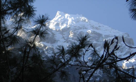
deep ravine cradling the river Bhagirathi is seen alongside. The snow peaks of Shivling is crystal clear in bright sunny weather
against the backdrop of cloudless blue sky. The atmosphere is apparantly low in oxygen. Breathing through mouth is
a necessity to progress at a reasonable pace. Even at 10,000 ft and above the sun can be pretty harsh on the exposed
skin. Taking off windcheater off the sweaty body; I proceed at my own pace. Sanjay as usual left me far behind. Sen is
following me. The trekking season is just beginning early May. There is only one wayside stalls till
now , selling tea, snacks and mineral water and soft drinks. I have a Mirinda bottle; from which I am taking seeps
from time to time. Mouth is incresingly becoming parched. Arrived at Cheerwasa after 4 hours of trek. Cheerwasa
consists of very few houses and is full of cheer ( pine ) trees. In fact it can be called 'alpine grandeur '. The Bhagirathi
peak seen through pine trees make a lovely sight. We come across a few foreigners resting at a shelter. Also come across
a lot of tourists trekking or riding horses returning from Gaumukh. The common observation was; everybody has a very
red face and all exposed part of skin is red. May be it has something to do with ultraviolet radiation from Sun at high
altitudes. Our pittoo spot a group of Bharals and asks me to photograph them.
( It is a common sight for trekkers to come across the Bharal - the Himalayan blue sheep - grazing in the alpine pastures.
However, in spite of of its name, the Bharal is neither blue nor a sheep. It is a cross between a sheep and a goat, but is
larger than either. It has rounded and smooth horns that curve backwards. Incredibly sure footed, Bharals usually graze over
14,000 ft coming down lower only in the winters. They move around steep crumbly mountainsides, and move about in large herds.
As a result, it is usually only the trekkers who get to see these animals).
We were lucky enough to see Bharals at 10,500' during our trek. Our second destination Bhojwasa is some 5 km
away. We cross three make shift wooden bridges over mountain streams. The bridges are either two logs placed side by
side or a ladder kept horizontally over the stream. It was somewhat scary! After two hours of trek we sight Bhojwasa.
From top we see Bhojwasa as three cluster of houses. One GMVNL guest house; the second Lal Baba's Ashram and the third, a
shelter for porters and ponywallas. We are sceduled to spend tonight at GMVNL guest house. For time being we bypass
Bhojwasa.
The Bhagirathi enroute is a fast moving narrow river. After trekking for 14 km in blazing sun, I felt a mild headache.
That was a bad sign. I have another 8 km of trekking to do before I call it a day at Bhojwasa. Bhojwasa is situated at
12,500 ft and Gaumukh at 12,960 ft. though the ascent is not much but the trail leaves much to be desired. The narrow track
and lack of any vegetation makes it a bleak country. There is not a blade of grass. There are huge number of boulders of various
sizes unevenly scattered across the terrain. On one side there is hill and on the other side deep gorge. At some places the
track is blocked by loose dry soil falling down the slopes of the hill. But it is more than made up by the majestic Bhagirathi
peak, the Shivling peak and other Himalayan peaks. The Bhagirathi river gets narrower as we approach the source. The water
is brownish grey in colour carrying a lot of silt with it , in tune with the surroundings. Two km from the source
we come across a makeshift Shiva temple, with no roof and no pujari. Meet Sanjay and Sen returning from Gaumukh. Sen had taken
a horse from Bhojwasa as he found the going tough. See an interesting bird hopping around. It is a black crow with yellow
beak. I just miss out on taking a shot. Our pittoo who is with me through out is particularly helpful in the
last part of the journey. When we were struggling with our trek, pittoo was carrying all our backpacks and singing and walking
with ease. Such is the adaptibility of these mountain people. We observe the Gaumukh glacier from a few km away. When finally
we arrive at the Gaumukh zero point, the glacier and cave is some 1 km away. The glacier above Gaumukh ( cow's
mouth) is actually grey in colour with so much of mud and dust collected over it for decades. A narrrow stream emerging from
the snout in form of Bhagirathi river. Now onwards the trail is just 12 inches and most of the places there is no trail. I
come as close to 300m and get a reasonably good view of Gaumukh. Pittoo goes to Bahgirathi to collect some 'Ganga Jal'
for my home. The return trek to Bhojwasa is uneventful. I have to be extra careful when descending rocky trail. The deep
gorges alongside narrow trekking path demands a full concentration from trekkers. Come across a lot of foreigners, greeting
us with 'namaste'. This is one Hindi word their guide must have taught them. The foreigners seems to outnumber resident Indians in
trekking this side of Garhwal Himalayas. Such is the aura of river Ganges and its Source across the world.
By the time I reach Bhojwasa , my headache increased and was acompanied by loads of bile/acid collected in
my stomach.
This could be a high altitude sickness.
The best option was to get rid of it. Which I did and dived into the bed provided in tent for us. There are 8 beds
in the tent. Myself, Sanjay and Sen occupying three and rest by foreigners. The amenities are bare minimum at the guest
house with no running water. How these 'whites' manage it in these situations is a mystery to me. It is 5 pm by
now. We have walked today 22 km for the duration of nearly 10 hours. Badly needed rest for a couple of hours. When I am
ready to go for dinner, I just could not move. All my leg muscles became so sore and painful. Every movement was agonising.
With great difficulty I dragged myself to canteen. The dinner is simple Chapati and sabzi. Before going to
bed I am in a dilema for next days 14 km trek to Gangotri; whether to take horse or trek it. Trekking appeared rather
a very remote possibility with todays exhausting experience.
9.5.2006
Got up early with a headache. However the soreness in leg muscles was gone. Had some tea and biscuits and took
a painkiller for the headache. Within half an hour I was feeling better and decided to take 14 km trek back to Gangotri. I
wanted to take it easy since we were scheduled to leave Gangotri for Bhatwari only at 3 pm. I had for company this time
the Sabnis couple. Once again we had to cross those creaky wooden ladders across the streams. I filled my water bottles with
crystal clear spring water. The water pouring down the hills is consumed in entire Garhwal region and it is as pure as it
can be. No need for mineral water. Since we were going downhill, we made it in good time. By 1 pm I could sight the Gangotri
town and Bhagirathi river meandering through the town. I took some good shots of the temple at various altitudes and
staggered to the guest house. We were greeted by Mishraji who had skipped the Gaumukh trip and took custody of our luggage.
Had a hot water bath and then Sanjay took me to a restaurent which was by far best at Gangotri. They even served Masala Dosas
here! I had a large meal this time and came back to guest house. At 3 pm we checked out and boarded bus to go to our next
destination Bhatwari some 75 km off. When we arrived at Bhatwari ; there was a pleasant surprise. The GMVNL guest house
looked spankingly new. We had to go down quite a bit to check in to our rooms. We got a four bedded room and the amenities
were simply too good compared to what we had so far. Ofcourse the tea and dinner had to be had in the town; so we ventured
out. After making STD calls to our homes; we had some tea and snacks. Sanjay, myself and Sen had an adda session till the
dinner time. Then we changed to another dhaba and had a simple dinner and trooped back to our room in the guest house. Our
fourth room partner Sinha was missing as usual. Nobody knows where he went during our breaks! Tomorrow we have a 320 km bus
ride for Chandrapuri.
For photos of Gaumukh trek log on to
and open the Gaumukh 2006 album
10.5.2006
We board the bus for our next destination Chandrapuri. By 9 am
we arrive at Uttarkashi , one of the most important towns of Uttaranchal. We have a breakfast in a regular aircooled restaurent
called 'Bhandari's. The Reliance network is operational here. So we got a chance to make a call to home from my cellphone.
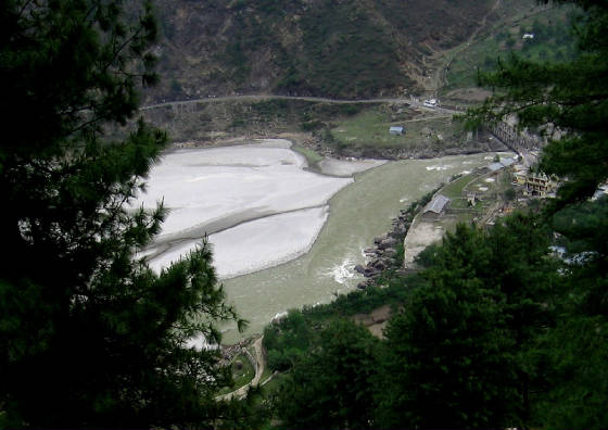
As we proceed we find Bhagirathi becoming broader and broader and get down the bus about few km from Tehri Dam. After stretching
our limbs and a few pictures later we continue with the journey. From bus we get a splendid bird's view of Tehri dam
. It is a spectacle. I never imagined that a dam can be so beautiful and picturesque! The gigantic Tehri dam on blue waters
of Bhagirathi kept our eyes glued. I wished to have videographed it from bus. Next time if I get a chance,
I will. The lunch break was on a hill top restaurent. Fed up of the regular fare of Roti, rice, sabzi, we venture out
to try the Veg Chowmein from the menu. Surprisingly it was a tasteful fare. I suggested Sanjay to try some sweet dish.
The Rasagullas were delicious too. By 8 pm we reached Chandrapuri, a small town or village situated on bank of Mandakini river.
It was raining very heavily. We drenched ourselves in reaching GMVNL guest house and had tough time getting to our rooms.
Our luggage arrived soaked in water. The loud roar of Mandakini was apparant because of proximity of the river. Our
room was situated on the back side fencing of the guest house. The river Manadakini was some 20 ft away. Fortunately the canteen
was serving food. We retire after dinner at about 10 pm. Tomorrow we go to Gaurikund and resume Kedar trek from there.
11.5.2005
We get up early in the morning to get a feel of the place. The
garden near the back fencing is full of beautiful flower plants.
The roaring river Mandakini beyond the fencing make a beautiful place to spend a few days. Alas we are at the mercy of
our package tour operators! With heavy heart we board the bus. We travel 67 km and by 9 am we arrive at Gaurikund.
Gaurikund being starting place for kedar trek, a very large number of pilgrims and tourists arrive by bus, jeep and car. The
place is a sea of humanity. Our guide takes us to GMVNL guest house for breakfast. The breakfast is noodles for me and Alu
Parathas for other friends. We make a final arrangement of a lighter back pack this time which we will carry with us. I pass
on my SLR to Sanjay, but I knew he will not take any pictures in order to reach Kedar in shortest possible time. It is going
to be my repeat Kedar trek after exactly 25 years. Gaurikund is at 6000' altitude and Kedar at 11,500' altitude.
Which means we climb 5,500' on a trek of 14 km ( 9 miles ). The gradient is pretty steep. As usual Sanjay takes
off at a brisk pace. Sen and myself decide to do the 14 km trek at our own sweet pace. In 1981 I did the same trek in
six and a half hours. This time I hope to do it in seven hours. But getting out of Gaurikund and hit the mountain trail itself
was an ordeal. The narrow streets were packed with khachhar wallas, palkiwallas and kandiwallas vying with each other
for customers; the pilgrims bargaing with those people. Palki is a palanquin carried by four persons and offers
most comfortable journey. kandis are cane/bamboo baskets carried on back and are mostly suitable for kids and old people.
The journey is not comfortable sitting inside a narrow basket with legs practically locked up. After some 20 minutes of jostling
with the crowd we hit the Kedar trail. The Kedar trail is quiet broad and paved with stones but the gradient is killing. Almost
the entire route has a large number of tea stalls and dhabas. They stock mineral water, soft drinks, fruitie, biscuits and
serve vegetarian lunch and surprisingly maggie noodles. They do not understand noodles. But Maggie brandname has even invaded
Garhwal hills. The first big habitat is 7 km away at Rambara. The trek was a continuous ascent. After every five
minutes trek we take a breather for a minute. After one and half hour we take a
fruitie break in one of those dhabas. Myself and Sen had a good chat together. Sen, four years younger to me seem
to get inspired seeing me do the trekking; but all the same lamented that the smoking has reduced his lung power
to a great extent. By now we get used to the horsesheet smell, the laboured breathing of palkiwallas, the spring
water flowing across the road, the river Mandakini meandering along the rocky terrain, the khachchar riding youths waving
us with 'Jai Kedarnathji ki' , the cocoonlike existance of children riding kandi ( basket ) and our own muscular pains. By
1 pm we reach Rambara. The place has a GMVNL guest house. We failed to locate it and settled for a Dhaba. I ordered Maggie
with onion and tomatoes and had a good fifteen minutes breather . The weather so far had been sunny all the way.
But suddenly as it happens in the mountains, it became cloudy and grey. We remember our guide telling us that, generally
there is rain after 2 pm in Kedarnath region and to reach as early as possible. But we knew we can not make it before 4 pm.
Hence we resign to the fate; that we will get drenched and shiver in severe cold at 11,500' to reach kedar.
The route from Rambara to Kedar is much steeper. We took rest of one minute at every bend in trail we encountered. As
we ascended higher; we were in cloud nine literally. The grey
coloured rain bearing clouds were sailing very close to us. The landscape below, had a different hue altogether. There
were clouds clinging to the mountainside. The horses grazing on the meadows, the unmelted snow on the hills around us
and Mandakini roaring its way down. Suddenly a few drops of rain fell. Without raincoats or umbrellas we were sitting ducks!
( if it rained heavily!). We tried to push on faster, but it was impossible. When look upwards we see four to five bends
of spiraling roads we have to traverse. After covering those, four more bends crop out of nowhere. After umpteen bends
we reach Garud Chatty about two km from Kedar valley. We take a final fruitie break before the final assault ( as if
we are climbing Mount Everest! ) . The weather was getting murkier but fortunately no rain yet. Next one km was some
how covered till we hit the Kedar Valley. The flat land bring less discomfort to our legs and also
also bring cheers to our soul. We get a glimpse of Kedar township through the haze. By now the valley was filled with
so much cloud and fog, the trekkers following us at fifty feet were looking like ghosts. I ask Sen to take a picture
of me in identical pose and walking stick on the ground just like 25 years ago. I was glad to have repeated the
history! As we proceed for the town we pass through the camp of Khachcharwallas; group of shops selling various items and
a few dhabas. Sen purchases potato chips for munching along with tea. It took awhile to locate GMVNL guest house. It is a
huge spawling area with so many rooms added over the years. I enquire about Sanjay who has reached probably hours earlier.
With a lot of effort the staff locates the double room he has already occupied. It is 4.30 pm and slightly dark inside the
room. I call out for Sanjay and he grunts from his bed lying in warm comfort of blanket and rajai. I wash my face and
again call Sanjay for a cup of tea and snacks as I am ravishingly hungry, but Sanjay was in no mood to budge. So I go out
and look for Sen. He too was not traceable the 'hyper' that he is! So I alone head for the canteen. There is a power
failure. I order for tea and veg pakoras and think what to do next. The tea was refreshing and pakoras really
tasty and I wolf it down in no time. Still there was no rains. So I venture out . The fatigue of trek was gone. The Kedar
valley, with mountains full of snow, large green medows, wild flowers, the river , and paved cement tracks, is one of
the most picturesque places I have seen in my life. I wonder aimlessly in the valley soaking into the divine
surroundings. I spot the Om temple and make a visit. I think of visiting kedarnath temple tomorrow and return to my room.
Sanjay is still sleeping. I decide to take a few hours rest before the dinner. Climate is becoming very chilly. Under bkanket
and rajai is best place to be in. After simple dinner we hit the hay.
12.5.2006
As usual I woke up very early to get as much time as possible
at Kedar valley till we descend to Gaurikund. As we come out of guest house there is heap of snow near the entrance.
Sanjay adds 'it must have snowed heavily some two weeks back'. We visit Kedarnath temple and shoot a small video. There
is devotional music in the loud speaker . Devotees throng to offer puja and some for just having darshan. The temple
is made up of off white stone and perfectly blends with the surrounding snow capped hills. After breakfast at the guest
house, it is time to continue with our downward trek. The weather is all sunshine. Sanjay this time agrees to give me
company and Sen too. Three of us bid good bye to Kedarnathji, promising to come back again. Sanjay this time takes in
charge of SLR and I continue with my digicam. We make it nice and slow. There is not much effort now . We come to a
waterfall originating some thousand feet above and cascading down below the bridge where we stood. I shoot a video of the
scene. There is also good opportunity to shoot the serpentine trail and the devotees continuing with their effort to
reach the shrine. We pass Garudchatti , and arrive at Rambara after some three hours. It is 10.30 am. I have my
usual noodles in dhaba and shoot some video of devotees and pilgrims passing by the dhaba. After a good 15 minutes break
we decide to increase our speed of descent and try to reach Gaurikund by 1 pm, so as to enable us to catch the bus at 2 pm.
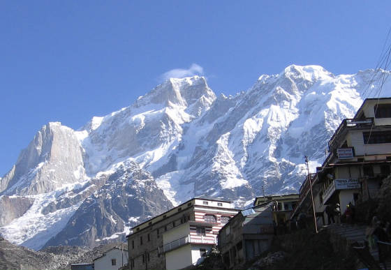
By 12.30 pm we make it to the chaotic place called Gaurikund. We straightway go to GMVNL to have a bite to eat. By 2 pm we
were at the bus stand. But there was no bus for good half an hour. At 2.30 finally we get news that the bus is parked 1 km
away from the spot. We trek the distance and board the bus. At 5 pm we reach a place called Guptakashi. We are offered
a four bedded room. After tea at the guest house we venture out to see a temple of Shiva, which is a replica of Kedarnath
temple. There we find Mr. Sabnis painting the picture of the temple. ( He is himself a drawing teacher ). I take a snap of
Mr. Sabnis with his painting. Then we venture out to town for a cup of tea. The teastall owner says that , yesterday there
was heavy rain for two hours and water was about to enter his shop and huge amount of mud had collected in the road and traffic
was greatly affected. Now we understand the secret of rains eluding us at Kedar and taking a detour to lower reaches of Himalayas.
For photos of Kedarnath trek log on to
and open the Kedar 2006 album
13.5.2006
Today we have to reach Badrinath by bus in the evening.
We start early in the morning and by breakfast time we are at
a place called Chopta. This place is one of the most scenic places I have ever visited. There is 180 degrees panorama
of Himalayan peaks. In the cloudless bright morning the view was majestic. The habitat contains a few bunglows, a few dhabas
and a few shops. The place has vast stretch of green meadows. Somewhere there is a board written
'Mini Switzerland' . I feel slighted by it. Perhaps colonial hangover! According to me nothing can be better than
Himalayas. Switzerland ( Alps )does not come anywhere near.
Sen is so mesmerized that he promises to bring his family here some day. From here one can go by bus and then trek
to a place called Tungnath. That place is even better than what
we have seen so far. Maybe next time we will make a visit.
Sanjay has his tea while myself and Sen make use of the time to shoot some real good snowscapes. Some Alu Parathas
later we board the bus for Joshimatt. We have a lunch break here. Joshimatt is an important town of Uttaranchal. During
winter, when Badrinath temple shuts down due to snowfall,
the puja of God Badrinath is done here at Joshimatt.
By 4 pm we reach Badrinath. Again this is my second trip
in 25 years. The town has grown. The number of pilgrims has gone up many fold. Sanjay and myself get a double room
and
Sen and Sinha get another. While four of us were chatting over a cup of tea, suddenly Sinha spots the black crow
with yellow beak. I run to my room to bring the camera and when I
return it was gone. I go to the backside of guest house to locate it. But it had vanished. I feel dejected and philosophise
"Himalayas give you a lot but hold back some, so that you will visit again!" . There was still time for before light
faded. So we decide to go to the Mana Village at China border which is some 3 km from Badrinath. A jeep hire for Rs.20/- per
person takes three of us to Mana village. We visit 'Vyas Gumfa' and settle down for a cup of tea at a shop called the "India's
last tea stall". Beyond Mana village falls the Military Area at the India-China border. We wait for the jeep driver
to arrive. He has possibly gone to wet his parched throat some where in the village. The dusk was falling. All the jeeps were
returning back to Badrinath. We had a mini crisis in our hand. Even if we trek back it will take atleast an hour and we have
to cross some mountain streams in the falling light. Not a encouraging proposition for me with one of my eye blurred
with cataract.
Sanjay and Sen manage to arrange my transport with one of the jeeps and start to trek the 3 km back to Badrinath town.
I reached Badrinath guest house and waited for the guys to arrive. To my pleasant surprise they arrive within 15
minutes.
They were picked by the jeep half way through. But that did not prevent Sen to hurt his leg while crossing a mountain
stream. I arranged some first aid for Sen and we headed for
the temple. There was aarati going on with large turnout of enthusiastic devotees. After tea and snack in
nearby restaurent, we head back to guest house.
14.5.2006
In the early morning we prepare to go to Badrinath temple for darshan. Sen narrates an interesting incident about
his room mate S.K. Sinha. Sinha woke up Sen at 2 am in the morning and said that he saw a UFO stationed on the
top of the hill. Also the UFO has been following him since childhood. Sinha prodded Sen to accompany him and see the
UFO on hill top. An exasperated Sen pleaded with Sinha to go back to sleep!
I was waiting for daybreak to photograph Neelkanth peak.
With the first light of dawn, the Neelkant ice cap looks
whitish grey. I thought 'that is it' and was disappointed . This is not what I had expected. After nearly 20 minutes,
as if by sheer magic the whole Neelkanth peak changed colour and became golden yellow! My day was done. The SLR and digicam
were kept busy. Finally it was time to say adeu and we boarded the bus to go back to Joshimatt. At
Joshimatt we visit Jyotirmatt and we go to ropeway station to take the cable car to go to Auli. After purchasing ticket
we have 15 minutes before the cable car departure. We taste first non veg stuff in last 11 days. It was just egg chow
mein. The cable car is spacious to carry 15 passengers. As we ascend we watch the landscape, the small houses
on the hills, the horses and sheeps grazing on the medows. After 45 minutes and 3000' ascent we arrive
at Auli. Auli is actually one of the finest ski resorts in Asia. In winter there is 8 to 10 feet of snow. Now ofcourse
it was all green meadows with panorama of Nandadevi peak and other important peaks of Himalayas. The cable car station runs
a canteen and we sit in the sun in plastic chairs and savour the Himalayas. We have 2 hours time to spend here before
we begin the return trip. After some photoshooting we touch Joshimatt by cablecar. After some tea all of us wait
in the bus for journey to commence. But Sinha is nowhere to be seen. A visibly tense Negi the guide goes to cable car station
to locate Sinha. After good half an hour Sinha is traced and every body gives a sigh of relief!We reach Nandprayag
in the evening. It was too late to have a dekko of the confluence. Hence we decide to see the prayag from the bus next
morning.
15.5.2006
We start at 7 pm for our return journey to Rishikesh. Enroute
we have a 5 minutes break to see and photograph Rudraprayag. Rudraprayag is confluence of rivers Alaknanda
and Mandakini . The colour of the rivers are so distinctly different that it is a visual delight. Wish we had more time to
spend here. Our next halt is at Deoprayag. Deoprayag
is the confluence of rivers Alaknanda and Bhagirathi. the township on the hills looks very pictureque.
Finally we arrive at Rishikesh by 4 pm and complete our eleven days package tour. Time to say good bye
to each of our bus passengers. Some leave with us their addresses for
contact purpose. Myself , Sanjay and Sen return on the same day to Hardwar. At Hardwar we take leave of Sen who
was such a good company. The Himalayan trek bug has really bitten him! He wants to return to Himalayas again.
After seeing aarati at Har ki Pairi and a very tasteful dinner we are back to hotel. Tomorrow we go to Delhi to
catch Rajdhani Express to reach Home Sweet Home, Mumbai.
For travel photos log on to
and open the Travel 2006 album
..................................................